| |
| |
|
|
| Title
| Background
| Methods
| Objectives
| Project Schedule
| Reports
| Co-operations
| Contact
| Participating Scientists
| Funding
| Time Frame
| References |
|
|
|
|
Research into the Sensitivity of Fragmentation Metrics
|
| |
|
|
|
|
|
 Background Background |
 Forest fragmentation has lead to the disruption of ecological processes and in many cases to the degradation of the natural
resources. This makes it relevant for forest and conservation policy as it is among the key indicators for sustainable forest
management on the landscape scale, where a relationship between fragmentation and ecological, conservation and economic
issues is assumed. Also within the framework of international policy processes, like the Convention on Biological Diversity (CBD) or the Convention on Climate Change, monitoring of forest fragmentation comes into the focus of decion makers. It has been subject
of intensive research during the past decades (e.g. Millington et al. 2002, Lindenmayer et al. 2002, Riitters et al. 2002).
Forest fragmentation has lead to the disruption of ecological processes and in many cases to the degradation of the natural
resources. This makes it relevant for forest and conservation policy as it is among the key indicators for sustainable forest
management on the landscape scale, where a relationship between fragmentation and ecological, conservation and economic
issues is assumed. Also within the framework of international policy processes, like the Convention on Biological Diversity (CBD) or the Convention on Climate Change, monitoring of forest fragmentation comes into the focus of decion makers. It has been subject
of intensive research during the past decades (e.g. Millington et al. 2002, Lindenmayer et al. 2002, Riitters et al. 2002).
To evaluate forest fragmentation and its link to ecological processes, quantification is in demand. While there is no
intuitive or immediate approach, various fragmentation metrics have been proposed which are calculated from a combination
of directly measurable variables such as patch area, edge length, number of patches, dominance, diversity, contagion,
fractal dimension and others. Special software has been developed, such as Fragstats (McGarigal et al 2002), APACK
(Mladenoff and DeZonia 2004), Patch Analyst (Elkie et al. 1999) and r.le in the GRASS environment (Baker and Cai 1992) to
calculate a variety of indices or metrics. This has lead to an increase in quantitative landscape analysis
in the last years, since easy to use software is freely available.
However, the sensitivity of fragmentation metrics has attracted less attention in the scientific literature than the
development of new metrics (Millington et al. 2002), although - as with any other indicator - this sensitivity is an
important piece of information for comprehensive interpretation. Factors of relevance for the calculation and interpretation
of fragmentation metrics and their sensitivity include:
- Spatial resolution
- Class definition
- Boundary definition
- Topography
Tropical and subtropical forest are under special interest of conservation and climate change policies as they are
hot spots for both biodiversity and carbon sequestration and at the same time they are facing big threats to be converted
to other landuse systems. Remote sensing is one of the key technologies for forest cover and thus forest fragmentation assessments as it provides the possibility to monitor large areas with a reasonable effort. Today a hugh amount of land cover classification system exists and are widly used but most of them do not apply a specific class or boundary definition based on quantitativ criteria. Thus, a comparison of the land cover maps and derived fragmentation metrics in space and time from different providers is often not possible.
|
|
| Objectives |
Overall objective of this study is to research into the sensitivity of fragmentation metrics to
the factors described above and to contribute to a more focused and more differentiated
interpretation of fragmentation metrics. The potential of two new German satellite systems TerraSAR-X and RapidEye for forest fragmentation assessments in the subtropics and tropics will be analysed with special focus on implementing specific forest definitions during image classification. While this study takes forest and forest fragmentation
as an example, it is a general methodological study and the results can immediately be applied
to the fragmentation status of any other land use or land cover class.
|
|
| Methods |
To achieve the described goals the project is structured into two main sections
- Simulation and Modelling
 This part seeks to examine fundamental linkages between the mentioned factors and the fragmentation metrics.
Based on fundamental geometric considerations the simulations will be performed on artifical landscape
models utilizing stationary isotropic Gaussian random fields (Schlather 2001). The derived landscape models
will be classified to binary forest / non-forest maps according to different forest and forest edge definitions.
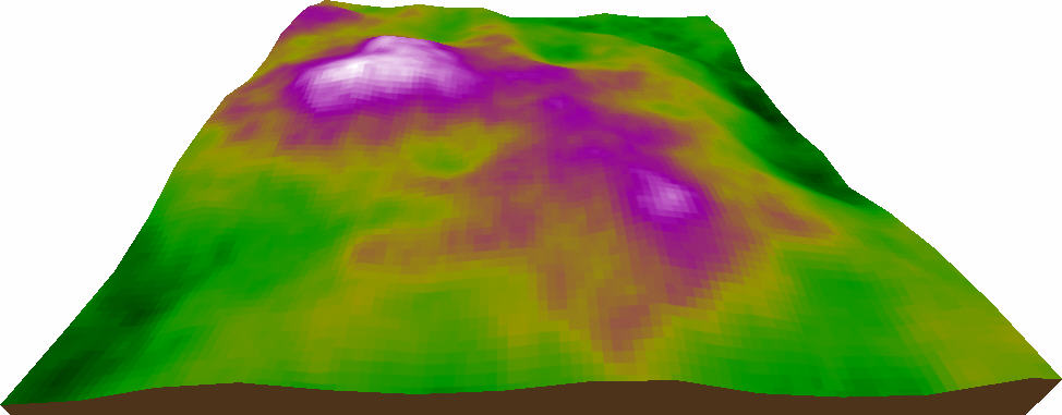
This landscape maps will be combined with a set of digital elevation models (DEM) in a geographic information system (GIS)to get insight into the influence of topography on fragmentation metrics. For calculation of the 3D patch metrics we devloped the software Patch3d .
This part seeks to examine fundamental linkages between the mentioned factors and the fragmentation metrics.
Based on fundamental geometric considerations the simulations will be performed on artifical landscape
models utilizing stationary isotropic Gaussian random fields (Schlather 2001). The derived landscape models
will be classified to binary forest / non-forest maps according to different forest and forest edge definitions.
This landscape maps will be combined with a set of digital elevation models (DEM) in a geographic information system (GIS)to get insight into the influence of topography on fragmentation metrics. For calculation of the 3D patch metrics we devloped the software Patch3d .
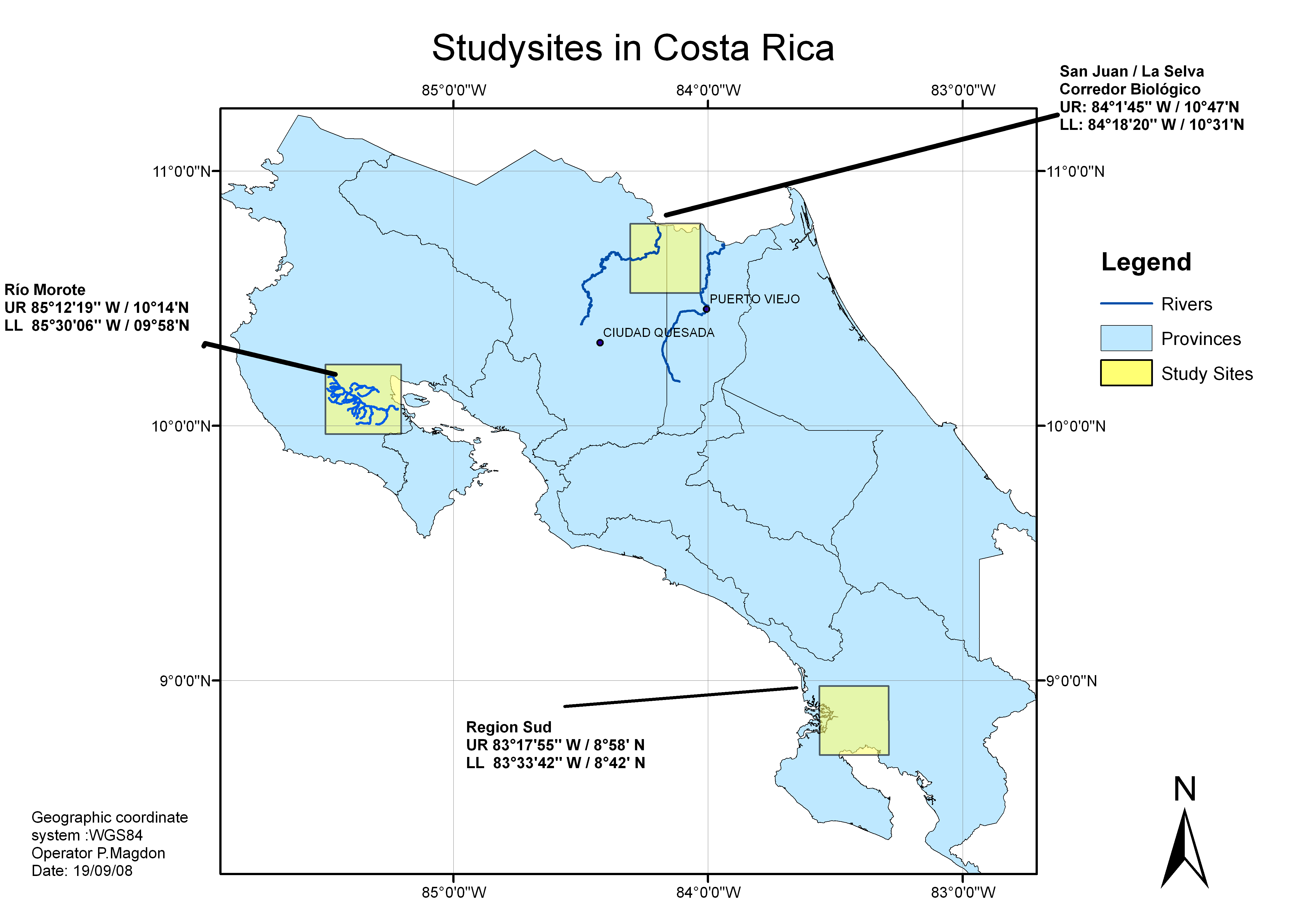
- Case Study : Costa Rica
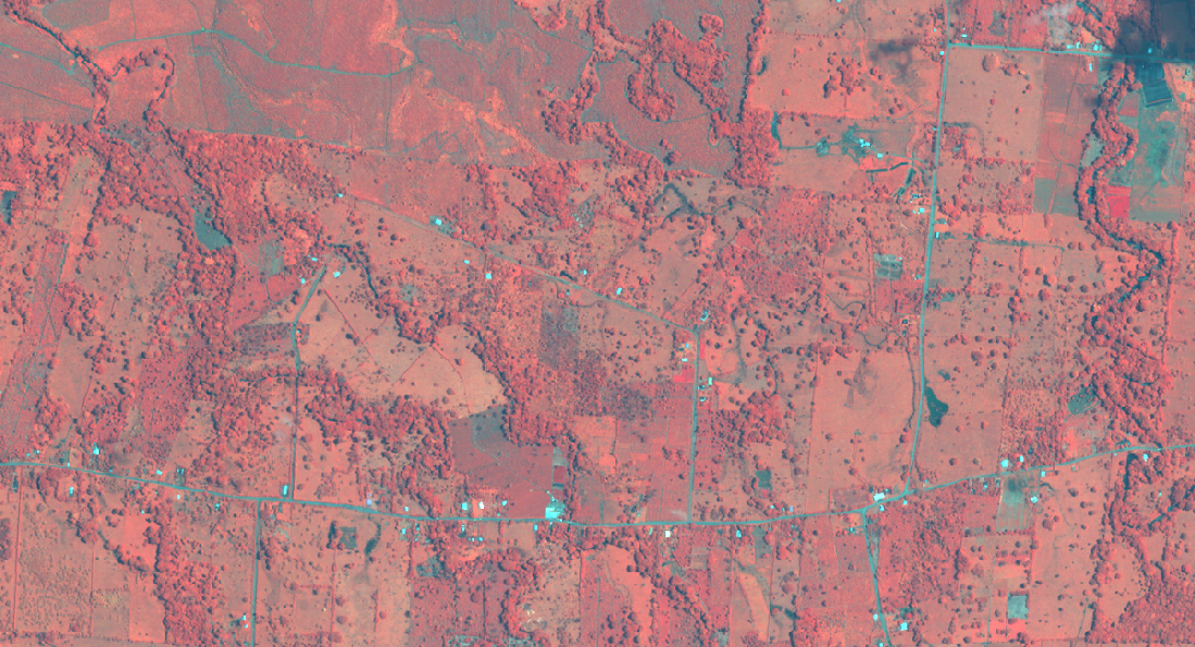
 Fragmentation analysis will be carried out for two study sites (30x30km) in Costa Rica. This will involve a variety of remote sensing products including aerial images, RapidEye and TerraSAR-X data. Different segmentation and classification techniques will be tested to produce forest / non-forest maps representing various forest and forest edge definitions. Based on this maps fragmentation analysis will be carried out, involving the use of DEM's with different vertical and horizontal resolutions.
|
|
| Project Schedule |
| 05/08 – 05/09: |
Simulation studies based on artificial landscape modells and artifical DEM's |
| 01/09 – 04/09: |
Acquision and preprocessing of remote sensing data incl. RapidEye and TerraSAR-X |
| 05/09 – 12/09: |
Radar and image processing including segementation and classification |
| 01/10 – 04/10: |
Fragmentation metrics analysis |
| 05/10 – 06/10: |
Field trip for forest edge measurments and ground truthing |
| 07/10 – 12/10: |
Investigating links between fragmentation metrics and biodiversity/ecology |
| 12/10 – 07/11: |
Statistical analysis and reporting |
|
|
| Publications |
Magdon, P. and Kleinn, C. 2012. Uncertainties of forest area estimates caused by the minimum crown cover criterion : -a scale issue relevant to forest cover monitoring. Environmental Monitoring and Assessment, DOI:10.1007/s10661-012-2950-0. Open Access
Magdon, P., Fuchs, H., Fischer, C. & Kleinn, C. (2010). Forest cover monitroing using RapidEye: a case study in Costa Rica, Monographie 3. RESA Nutzerworkshop, Neustrelitz
Magdon, P., Kleinn, C., Beckschäfer, P. & Schlather M. (2011). Uncertainties of Forest Mapping Caused by the Minimum Crown Cover Criterion - A critical scale issue. Conference on Spatial Statistics, 23-25 März 2011, Enschede, The Netherlands
Magdon, P. & Kleinn, C. (2011). Einsatz von 3D Landschaftsstrukturmetriken zur Erfassung der Waldfragmentierung -Simulationsstudie zur Analyse kritischer Faktoren-. IALE-D Jahrestagung 12-14-Oktober 2011, Berlin
|
|
| Co-operations |
 |
Centro Mesoamericano de Desarrollo Sostenible del Trópico Seco, Universidad Nacional, Costa Rica |
 |
Centro Agronómico Tropical de Investigación y Enseñanza, Costa Rica |
 |
Leibnitz Institut für ökologische Raumentwicklung , Germany |
 |
Deutsches Zentrum für Luft- und Raumfahrt, Germany |
|
|
| Contact |
| Project Coordinator |
Project Researcher |
| Prof. Dr. Christoph Kleinn
Abteilung für Waldinventur und Fernerkundung
Büsgenweg 5
37077 Göttingen
Tel. +49 551 39 3472
ckleinn@gwdg.de
| M.Sc. Paul Magdon
Abteilung für Waldinventur und Fernerkundung
Büsgenweg 5
37077 Göttingen
Tel. +49 551 39 9835
pmagdon@gwdg.de
|
|
|
| Participating Scientists |
The ForestEye working group
|
|
| Funding |
DFG (Deutsche Forschungsgemeinschaft)
|
|
| Time Frame |
May 2008 – June 2011
|
|
| References |
Baker, W.L. & Cai, Y. (1992). The r.le programs for multiscale analysis of landscape structure using the GRASS geographical information system. Landscape Ecology, 7(4),291-302
Elkie,P., Rempel, R. & Carr, A. (1999). Patch Analyst User's Manual. Ont. Min.
Natur. Resour. Northwest Sci. and Technol. Thunder Bay, Ont. TM-002
Lindenmayer, D., Cunningham, R., Donnelly, C. & Lesslie, R. (2002). On the use of landscape
surrogates as ecological indicators in fragmented forests. Forest Ecology and Management,
159:203-216
McGarigal, K., Cushman, S. A., Neel, M. C. & Ene, E. (2002). FRAGSTATS: Spatial Pattern Analysis Program
for Categorical Maps, www.umass.edu/landeco/research/fragstats/fragstats.html
Mladenoff, D. & DeZonia, B. (2004). APACK 2.23 Analysis software. http://flel.forest.wisc.edu
Millington, AC., Velez-Liendo, XM & Bradley, AV. (2002). Scale dependence in multitemporal
mapping of forest fragmentation in Bolivia: implications for explaining temporal trends
in landscape ecology and applications to biodiversity conservation.
ISPRS Journal of Photogrammetry and Remote Sensing 57,289-299.
Riitters, K., Wickham, J., O'Neill, R., Jones, K., Smith, E., Coulston, J., Wade, T., & Smith, J. (2002)
Fragmentation of Continental United States Forests. Ecosystems 5,815-822
Schalter, M. (2001). Simulation of stationary and isotropic random fields. R-News,1,18-20.
Landscape Ecology, 15, 661-678.
|
|
|
 Forest fragmentation has lead to the disruption of ecological processes and in many cases to the degradation of the natural
resources. This makes it relevant for forest and conservation policy as it is among the key indicators for sustainable forest
management on the landscape scale, where a relationship between fragmentation and ecological, conservation and economic
issues is assumed. Also within the framework of international policy processes, like the Convention on Biological Diversity (CBD) or the Convention on Climate Change, monitoring of forest fragmentation comes into the focus of decion makers. It has been subject
of intensive research during the past decades (e.g. Millington et al. 2002, Lindenmayer et al. 2002, Riitters et al. 2002).
Forest fragmentation has lead to the disruption of ecological processes and in many cases to the degradation of the natural
resources. This makes it relevant for forest and conservation policy as it is among the key indicators for sustainable forest
management on the landscape scale, where a relationship between fragmentation and ecological, conservation and economic
issues is assumed. Also within the framework of international policy processes, like the Convention on Biological Diversity (CBD) or the Convention on Climate Change, monitoring of forest fragmentation comes into the focus of decion makers. It has been subject
of intensive research during the past decades (e.g. Millington et al. 2002, Lindenmayer et al. 2002, Riitters et al. 2002).